An astronomically planned Bronze Age cemetery in Mid Wales. Deployed along three north/south hill ranges in the parish of Llananno is the most developed prehistoric astronomical complex yet identified in Britain. Similar to the great mortuary landscapes of Ireland, at Loughcrew, Carrowkeel and the Bend of the Boyne the Llananno ritual landscape spreads across many square miles of open hilltops. On the summits of several hills on the eastern and western ranges of the Llananno high ground many tumuli and cairns are visible with the unaided eye on a clear day. On the central ridge, Brondre Fawr, clear evidence for careful deployment of Bronze Age stone settings may be found. Principally thes...
The largest man- made mound in Europe stands 39 metres high by the River Kennet in Wiltshire. Although it is an impressive statement in the landscape it can not be viewed from any aspect at distances greater than 500 metres or so as it sits on low ground by the river.
This enigmatic monument has been the subject of much debate and speculation. No burials nor cavities have been found despite several tunnels and shafts sunk into and through the heart of the construction. No ancillary settings or earthworks with clear associations have been identified in the surrounding territory. See: http://www.english-heritage.org.uk/daysout/properties/silbury-hill/
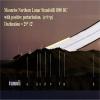
The most definitive summer solstice site identified by Alexander Thom must be the stone row at Ballochroy, North Kintyre. This dramatic stone row sits on the mainland hillside overlooking the Sound of Jura with it's central stone, a large blade or cleit, having it's two long faces clearly aligned on one of the high peaks, Corra Bheinn, on the mountainous island of Jura to the north west. From these stones, at the summer solstice of 1800 BC, (according to Thom's theodolite surveys), the upper limb of the solar disc, at sunset, would first graze the top of Corra Bheinn then slide down the long north flank before settling into the notch at the foot of the mountain. This demonstrates that the...
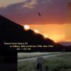
At the winter solstice 2005 a chain of high quality images were secured of the sun rolling down Carleton Bank from a camera position behind a small stone set in the apron bank of a Bronze Age tumulus. With images of this clarity we may ascertain with confidence the declination of the hill line of Carleton Bank and, with the formula- 0.72 arc minutes per century for Rate of Change of Obliquity- proceed to estimate at what time in the past the sun's upper limb first flashed down the entire slope of Carleton Bank. This might then be the actual date of construction of this solstitial alignment and the apron banked tumulus.
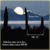
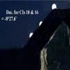
One Megalithic Calendar alignment for two dates has been confirmed by photography and digital extrapolation. Stone S2 Harlech to Rhinog Fawr's north face presents the declination for Calendar Intervals 10 & 16. We see that this fine menhir, S2 Harlech, has been dressed on the top to match the slope on Rhinog Fawr and further indemnifying this alignment with it's profiling of the pertinent place on the horixon.
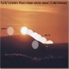
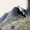
On the evening of the 13th April 2019 a photographic study was secured of the Sun's path on the western flank of Gop Hill cairn. A camera position was found from where the upper limb of the solar disc sat on the slope of Gop Hill cairn. Without moving the camera position successive shots were obtained of the solar upper limb rolling fully down the entire cairn flank. This demonstrates that the Angle of Obliquity has been conserved in the structure of this monument. If this angle has been maintained around the northern half of the mound, Gop cairn might be another example of a universal foresight, as with Silbury Hill, Wiltshire.